The Golden Age of Animal Tracking
Scientists may soon be able to monitor whole ecosystems in real time.
In 1804, a young naturalist named John James Audubon tied silver threads to the legs of the eastern phoebes, tiny white-and-brown songbirds, that lived in a nest near his home near Philadelphia. The birds soon flew away for the winter. The following spring, two returned with threads still attached. The experiment marked the first recorded use of bird banding in America, a technique for studying migration patterns.
More than two centuries later, technology, particularly the wonder of GPS, has turned silver threads into tags, sensors, and other devices capable of tracking all kinds of species around the world. Today, researchers get text-message alerts from collars worn by elephants in Kenya. They can stick tags on the shells of turtles or attach sensors to the fur of seals that transmit information with the help of satellites. They can even glue tiny barcodes to the backs of carpenter ants.
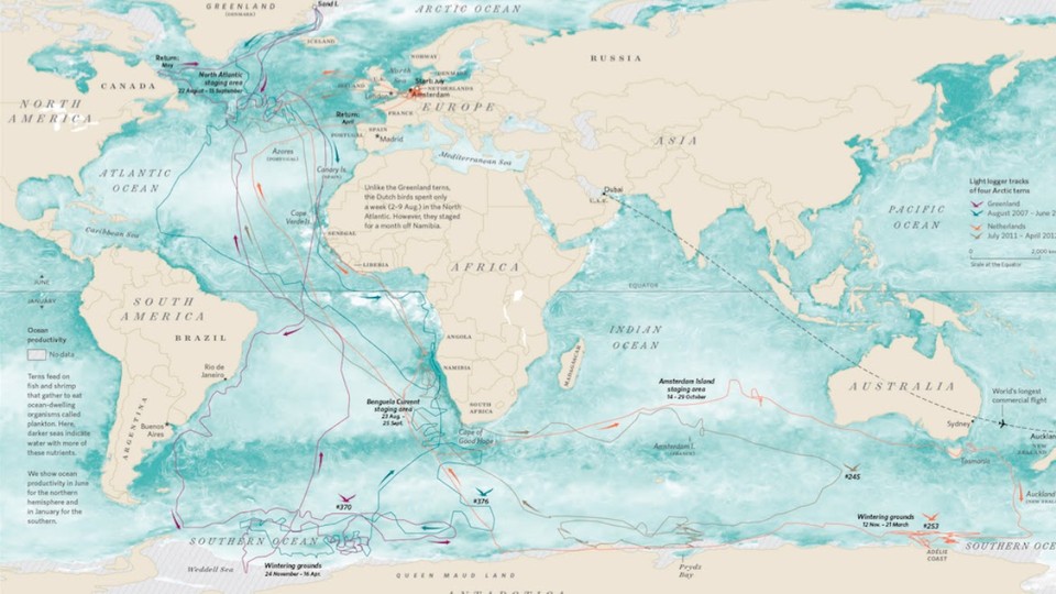
These are just a few of the projects described in Where the Animals Go, a book by geographer James Cheshire and designer Oliver Uberti, out this week in the United States. Cheshire and Uberti spoke to dozens of scientists tracking animals, from owls and elk to pythons and hyenas, and turned their data into a collection of 50 beautiful maps.
The maps show the paths the animals take as they cross desert, forest, ice, and ocean to feed, breed, and survive. The maps reveal what Audubon couldn’t see when he tied his silver thread to the birds: a journey. Some are especially quirky, as in the case of the seagulls who made daily trips to a city in France that was 40 miles away from their breeding colony. When researchers visited the site to investigate, they found the gulls feasting on discarded food outside of a potato-chip factory.
I spoke with Uberti and Cheshire about animal-tracking technology and the strange places it takes us. Our conversation has been edited for length and clarity.
Marina Koren: So your book introduces us to a fairly new era of tracking animals using technology. Can you tell me about the era that we’ve left behind? How did humans track animals before they could stick GPS tags on them?
Oliver Uberti: Until fairly recently, tracking involves looking for footprints, looking for fallen feathers, broken branches, droppings—any sign that an animal has passed through. Then around the past couple centuries, you start to get people like John James Audubon, who are tying threads to the legs of songbirds to prove that they’re actually returning to the same place every year. And then in the 20th century, you start to get people doing some real DIY tracking where they’re attaching cameras to pigeons or radio transmitters to a duck. But it’s only really been in the past 20 to 30 years that GPS has come on the scene, and then after that the miniaturization of computing power and the internet and satellites—it’s literally just exploded what you can do in a really tiny device.
James Cheshire: We’ve really transitioned from monitoring animals as a resource to be exploited to monitoring them as individuals within a species that we can collect a myriad of data from. Prior to the animal-tracking revolution, one of the biggest data sets collected on whales came from where we killed them, from whaling ship logs. There’s now sensors that they’ve got on whales that collect more data points than the sum total of the data collected in the previous five decades or more of research.
Koren: What kind of technology do we use today?
Uberti: There’s really no “one size fits all.” Scientists tailor tracking tags to the species and to the study, and that all depends on the environment that the animal lives in. GPS doesn’t penetrate underwater, so if you’re tracking a marine animal like a shark or a turtle, you need to have a device that can transmit when the animal comes to the surface and gets a brief, sometimes split-second window to shoot up to a satellite and transmit. Or you need a device that can release off the animal and float to the surface and then transmit. If you’re talking about songbirds, there’s protections in place to make sure they’re not taking tiny little songbirds that weigh only a few grams and saddling them with a giant computer. You talk about tracking plankton—you’re not even using a computer. You’re setting up an environment in an aquarium, you turn off all the lights, and you inject the plankton with a fluorescent particle like they use to track cancer in some medical technologies. And in the darkness, the individual plankton fluoresce and, by recording that with cameras, [scientists] can watch the illuminated animals move up and down the water column in response to UV light.
[At the Save the Elephants organization,] they can get text messages if they think elephants are in danger, if they’re moving too slowly, which is often a result of being shot by poachers or herders who’ve been scared because the livestock are coming close to these elephants and they don’t know what to do. If the animal is moving slower than it’s expected to move, the GPS tags notice and their accelerometers inside notice. It’s much like the way Google Maps can track different traffic patterns on the road by how fast they’re expecting you to be moving. If the elephant moves below a threshold, then it sends out an alert and Save the Elephants can dispatch rangers and law enforcement to check on the animal immediately.
Koren: How did you go about visualizing the immense data sets from the sicentists you talked to?
Uberti: When the data comes out raw from the tags, it’s an immense hairball. Tracks of many, many mountain lions, for instance, are all tangled on top of each other. To really tell any story of what the animals experienced or what the scientists are investigating, we try to turn big data into small data, and highlight one or two individual animals and walk you through or swim you through or fly you through what that animal experiences. It was a lot of editing down, taking out extraneous tracks, and really zeroing in on the lives of a few individuals.
Cheshire: Getting the right base-mapping information, all of the contextual stuff that goes around the tracks—that was a huge amount of effort, actually. It was probably more work than dealing with the actual animal data itself because we needed to make sure that what we were showing on those maps was relevant to that particular animal. We wanted to create maps that conveyed some of the environmental conditions. For example, when we mapped snowy owls over the Great Lakes, the satellite imagery we used for that roughly comes from the same time as when the owls themselves were flying over them, so you could see the same ice floes that the owls are seeing.
Koren: What was it like to look at a completed map, see a bunch of squiggles, and know that that’s an animal going about its life?
Uberti: This all goes back to an elephant named Annie, who I first mapped years ago. I saw where her GPS tracker stopped recording in [southeastern Chad], where she and a number of her companions had been killed by poachers. Mapping her moving through her environment, waiting till nighttime to cross the roads, to avoid interaction with humans, and then just watching her life stop on a map—that was the first time a map had connected me to an individual animal. It’s easy to think of animals when you hear about them, when you watch nature specials on TV, as furry robots that are just kind of preprogrammed, moving about the earth, doing what they as a species are assigned to do. And when you look at these tracks, you see in each individual path animals making decisions that are unique to them—what they like to eat, where they like to go.
Koren: The maps in the book really make clear how animal migrations transcend borders, whether it’s of national parks or nations. Has your idea of borders changed after seeing just how irrelevant they are for animals?
Uberti: It confirmed my own assumptions that borders don’t exist in the natural world. A great example of that goes back to the first GPS tracking study in Africa, where Cynthia Moss was doing research on elephants in Amboseli [in Kenya]. Some of her elephants were leaving and crossing the border into Tanzania into wildlife hunting ground and were being shot. When they confronted the Tanzanian government and the hunters about it, the hunters said, oh, no, these are our elephants in Tanzania, they’re not yours from Kenya. So Moss got Iain Douglas-Hamilton, the founder of Save the Elephants, and he put two [sensors] on two elephants, and sure enough, one of them crossed over the border into Tanzania. Here you had this undeniable proof that animals don’t follow human borders.
Border walls and pipelines make headlines, but far more insidious in their effect on animal behavior are freeways and fences. Mountain lions in Los Angeles are completely marooned on genetic islands in the Santa Monica and the Santa Ana Mountains because of this web of freeways, many of them eight, 10 lanes long, that the animal can’t get across. And if they can’t get an influx of DNA from animals from outside their population, they’re doomed by inbreeding.
Cheshire: It’s certainly true that animals don’t care about national borders, but the national borders themselves and the geopolitics around them still have big impacts on animals. We have a story about a wolf named Slavc who walked across Europe and starts in Slovenia and finishes in Italy and goes via Austria. Each of those countries had different laws and different attitudes toward large carnivores and whether they could be hunted. So for the researcher who was tracking Slavc’s progress, it was a real roller coaster, because as soon as Slavc stepped over the Austrian border, the chances of him getting hunted were bigger because there are laws there that mean you can shoot stray dogs. An animal doesn’t have to show a passport to cross from one country to another, but the impacts, when they do, can still have a big difference on their life chances.
Koren: What does the future of animal-tracking technology look like?
Cheshire: Stuff is going to get smaller and more powerful and cheaper to deploy. But the real interesting stuff is going to be what the researchers are able to do with the data when they get back to their labs, and start crunching through these big sets of numbers they’ve got, and see if they can look at the health of an ecosystem almost in real time. Researchers are now looking into how animals interact with one another, with predators, with prey. It’s those interactions that dictate how successful an animal is—are they getting enough food, are they able to hunt, are they able to breed? [Researchers] are beginning to tag enough animals within an ecosystem to see how those interactions are playing out.
Koren: Has working on this book changed the way you look at animals in your everyday life, even just a squirrel on the street?
Cheshire: For sure. There’s a tree in my backyard that has songbirds in it that come and go. Before, I didn’t pay them much attention, but now I’m wondering how long they’re going to hang around for, where they’re going to go, where they’ve been.
Uberti: The Wallace Stevens stanza that we excerpt kind of sums it up for me. “When the blackbird flew out of sight, it marked the edge of one of many circles.” Working on this book just made me think that way about all the animals I see in my day, whether it was a roebuck that jumped past me while hiking in Slovenia, to a lizard that skirted out from underneath a trash can here in Los Angeles, or the brown widow spider I saw last night outside of my flowerpots in my backyard. So much is happening outside of what we can see for ourselves.